Layout Detail. Layout Detail identifies the parameters within which the layout must be designed. It is broken down into two main elements: 5) Layout Design, and 6) Construction to build the railroad.
Prototye railroads use a variety of maps
to identify right of way information: track diagrams, rail and ballast information, drainage, superelevation
and grade line, bridge and building, and signal and communications
information. If you're fortunate to have chosen a prototype whose historical society has such maps then you are in luck. Here is my interpretatio of railroad information maps.
Engineering Maps. There are multiple examples of engineering maps. Here is one that focuses on survey information of the right of way, the track diagram includes tangent and curvature information and bridge and building information.

One of the things i found interesting was the surveying data. Railroad engineering maps apparently do use civilian surveying datapoints. The route distances are calibrated on official drawings and blueprints using “stations.” These 'stations' (not to be confused with railroad timetable stations) were measured in feet and were measured from a marker placed somewhere conveniently along the line, not always at a division point. Stations are 100 feet in length. Fractions of a station are denoted by the number of feet appended with a plus sign. Thus 320+45 would be 320 stations plus 45 feet or 3245 feet, which is 0.615 mile.My youngest son found this interesting, as he is a surveyor and he uses GPS data sets on a daily basis.
Mileage Maps. Here is another type of engineeering map. This map focuses on (from top to bottom) track curvature, grade, track diagram, bridge and signal locations and type. If youre modeling a specific prototype location, this information is invaluable.
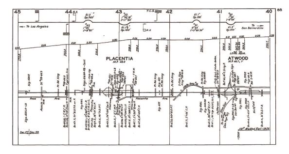
This mileage map displays similar information in a different format. The explanations legends are a great tool for modelers interested in the multiple types of buildings, bridge and rail used in prototype operations. I'm going to use this bridge and rail info for right of way information within this blog

There are other references to railroad activities . Here is an example of a Sanborne Insurance map that shows an industrial layout.

Here is an example of a cantenary engineering diagram. This will be of interest to me as one subdivision of the WWSL will be under wire.
You're also in luck if youre modeling the early 1900's. Back between 1910 and 1925, the US government required a valuation process for all railroads. Maps were created to document the track alignments, notes were taken on structures, cuts, fills, and bridges, and photos were taken of many structures and bridges. An amazing amount of these historical materials are available to researchers in the National Archives and Records Administration in Washington, D.C.
The WWSL
Southern Pacific Right of way and Structural Drawings
Southern Pacific Engineering Drawings
No comments:
Post a Comment